Welcome to the Your Say page for the Flinders to City Bikeway project.
Here, we aim to keep you informed about the latest developments and provide opportunities for you to provide your feedback.
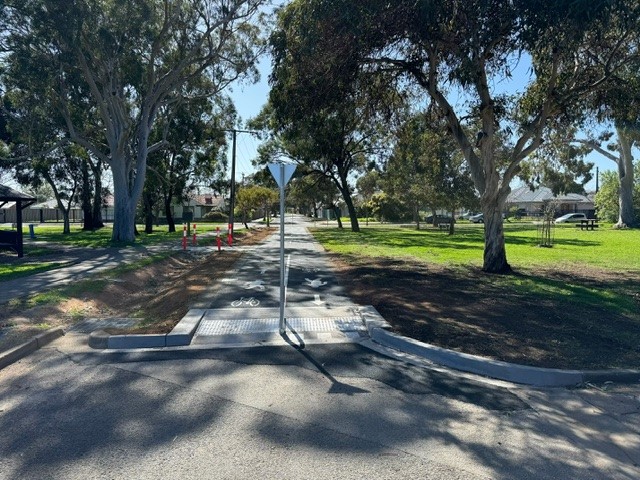
Stage 2 Between Daws Road and Cross Road
The City of Mitcham has successfully delivered Stage 2 of the Flinders to City Bikeway project between Daws Road and Cross Road. This new bikeway provides a defined shared route for both traffic and bicycle users and supports the immediate and long-term transport needs of our community by offering safer, more accessible options for active travel.
The new bikeway prioritises safety by providing a route designed specifically to support cyclists and other active travelers. With dedicated infrastructure, including designated bike lanes and safer crossing points, the Flinders to City Bikeway significantly enhances the active travel experience within our community.
Council values the feedback received from the community, with consultation undertaken in two stages in January 2021 and July 2024. All feedback responses were carefully considered during the design phase to ensure a safe, functional, and low-impact environment for both cyclists and local residents.
More information is available via the documents tab to the right and via the FAQs.
Consultation Outcomes
Thank you for providing your feedback on the Flinders to City Bikeway segment plans and for your patience as we worked through the detailed responses. We have prepared a Consultation Outcomes Report to summarise the feedback received and address some of the concerns raised by the community. This report can be found in the tab to the right of this page.
This report includes feedback on:
- Flinders to City Bikeway Route
- Improved Signage / Wayfinding
- Enhanced Greening
- Physical Barriers / Bike Lane
- Crossings
- Traffic Control
- Parking
From the feedback received, we have made changes to the following segment plans:
- Jose Street, Between Winston Court and Morgan Avenue (SHEET 05)
- Clovelly Avenue, Between Leith Avenue and Cross Road (SHEET 19)
- Overall Layout Plan to incorporate above changes
Updated plans are available in the Updated Segment Plans tab on the right of this page.
Nieass Reserve – Consultation Feedback Update
Thank you for the feedback and support regarding the Nieass Reserve adjustments. Based on community input, the following changes have been made:
- The design now includes only one bench, positioned closer to the tennis courts.
- The extent of the paving has been reduced to minimise heat retention during summer.
Additionally, we are proposing to install a drinking fountain and water bottle refill pole to support active travel and encourage sustainability.
The updated plan, showing these changes and the final layout, can be viewed in the Updated Segment Plans tab on the right of this page.
Thank you again for contributing to this important project.
Project Background
The Flinders to City Bikeway project aims to provide users with a safer means of active travel through the City of Mitcham. This new bikeway prioritises safety, offering a dedicated route to enhance accessibility and reduce potential risks for all active travellers. By addressing areas with high vehicle volumes and a history of accidents involving vulnerable road users, the project seeks to improve safety and accessibility.
While the existing Bike Direct Network serves its purpose, the Flinders to City Bikeway offers a separate route, designed specifically to prioritise the needs of cyclists and other active travellers. By providing dedicated infrastructure, such as designated bike lanes and safer crossings, the Flinders to City Bikeway significantly improves the active travel experience within our community.
This project is jointly funded by the City of Mitcham and the Department for Infrastructure and Transport (DIT). Council has facilitated the design of this portion of the Flinders to City Bikeway recognising the immediate and long-term transport needs of our community.
Construction Updates
The main construction of the Flinders to City Bikeway is planned to commence later this year, pending favourable weather conditions and contractor availability. We will keep you updated on our progress through this page, and directly impacted residents and businesses will receive further information via direct mail.
Rozelle Reserve
Construction of the Rozelle Reserve segment of the Flinders to City Bikeway began in August 2024 and was completed in September 2024. This segment includes bicycle ramps, a shared path, a realigned swale drain, improved line markings, and pedestrian paths connecting the playground and picnic areas, as shown on Sheet 09 For Information - Rozelle Reserve (Rozelle Ave to Penang Ave).
Where can you find more information?
Answers to a number of frequently asked questions can be found in the FAQ tab on the right. If you have further questions, please contact us at yoursay@mitchamcouncil.sa.gov.au or call 1300 133 466.
Flinders to City Bikeway - Survey
CLOSED: This survey has concluded.
Questions
CLOSED: This discussion has concluded. Outstanding questions will be answered as soon as possible and we apologise for delay. Please email yoursay@mitchamcouncil.sa.gov.au if you have any further comments.
Q&A
To ask a question you must create an account or log in.
These are the people that are listening and responding to your questions.
The Project Team
{{question.description}}


